Sitemap
| |
FAQ
Trumbull County OHGenWeb
History & Genealogy
Home
What's new
Information
Resources
Queries
Lookups
Links
Obits
Photos
Maps
>
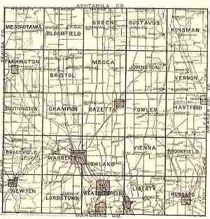
1899 Trumbull County Atlas Township Map
1899 Trumbull County Atlas Outline Map
Click to view map of Township.
The files are large (around 3 mb in size)in size,
so may take time to download.
Return to Map Index
site search by
freefind
advanced
Trumbull County Pages
Home
What's new
County Infomation
County Resources
Queries
Lookups
Links
Obits
Photo Album
Maps
History - NEW!
Trumbull County Neighbors
Ashtubula County
Formed From Trumbull and Geauga 1808
Geauga County
Formed in 1806 from Trumbull County
Portage County
Formed in 1808 from Trumbull County
Mahoning County
Formed in 1846 from Trumbull and Columbiana Counties
PA. Neighbors
Mercer County PA.
Crawford County PA.
Lawrence County PA.
USGenWeb Links
OHGenWeb Project
USGenWeb Project
Trumbull County Archives
OHGenWeb Archvies
USGenWeb Archives
Gallery
This page was last modified: June 2023
Research
Home
Information
Resources
Queries
Lookups
Links
Photo Ablum
People
Places
Post Cards
Year Books
Warren G. Harding H.S. 1927
Maps
Maps Index
Trumbull Site
Site History
Site Map